❌

Normal view

There are new articles available, click to refresh the page.
Before yesterdayMain stream

Archaeologists just mapped a Bronze Age megafortress in Georgia

A sprawling 3,500-year-old fortress offers tantalizing clues about a culture that once dotted the southern Caucasus mountains with similar walled communities.

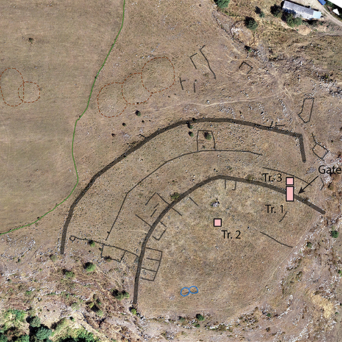
Archaeologists recently used a drone to map a sprawling 3,500-year-old fortress in the Caucasus Mountains of southern Georgia. The detailed aerial map offers some tantalizing clues about the ancient culture whose people built hundreds of similar fortresses in a mountainous region that spans the modern countries of Armenia, Azerbaijan, Georgia, and Turkey. Based on their survey and excavations within the fortress walls, Cranfield University archaeologist Nathaniel Erb-Satullo and his colleagues suggest the fortified community may have been a place where nomadic herders converged during their yearly migration, but the evidence still leaves more questions than answers.

gray map of a promontory between two gorges, with walls and buildings marked and labelled. This map shows an aerial map of the ancient megafortress at Dmanisis Gora. Credit: Erb-Satullo et al. 2025

An abandoned ancient megafortress

The half-buried Bronze Age ruins of Dmanisis Gora perch on a windswept promontory a few kilometers away from a cave where Homo erectus (or a close relative) lived 1.8 million years ago. Deep, steep-sided gorges run along two sides of the promontory, and sometime between 1500 and 1000 BCE, people stacked boulders into a double layer of high, thick walls to block off the end of the plateau from the plains to the west. Sheltered between the 4-meter high, 2.5-meter wide walls and the 60-meter-deep gorges, people built dugout houses, then later aboveground stone ones, along with stone animal pens and other buildings.

Read full article

Comments

Β© Erb-Satullo et al. 2025

Ancient fish-trapping network supported the rise of Maya civilization

On the eve of the rise of the Maya civilization, people living in what’s now Belize turned a whole wetland into a giant network of fish traps big enough to feed thousands of people.

We already know that the Maya turned swamps into breadbaskets by draining and building raised blocks of land for maize fields. However, a recent survey of a wetland in what’s now Belize suggests that the rise of the Maya civilization was fueled not just by maize but by tons of fish every year. University of New Hampshire archaeologist Eleanor Harrison-Buck and her colleagues recently mapped a network of channels and ponds for trapping fish, built just before the Maya civilization rose to prominence.

Fish in a barrel

Harrison-Buck and her fellow archeologists used drones and Google Earth data to map 108 kilometers of ancient channels that zigzag across 42 square kilometers of wetland in Belize’s Crooked Tree Wildlife Sanctuary. The result is a network of channels and ponds that looks remarkably like the fish traps found farther south in Bolivia, built several centuries after the ones at Crooked Tree. Radiocarbon dating of material buried in the bottom of one channel suggests that the network has been around for at least 4,000 years.

Read full article

Comments

Β© Fernando Flores

❌
❌