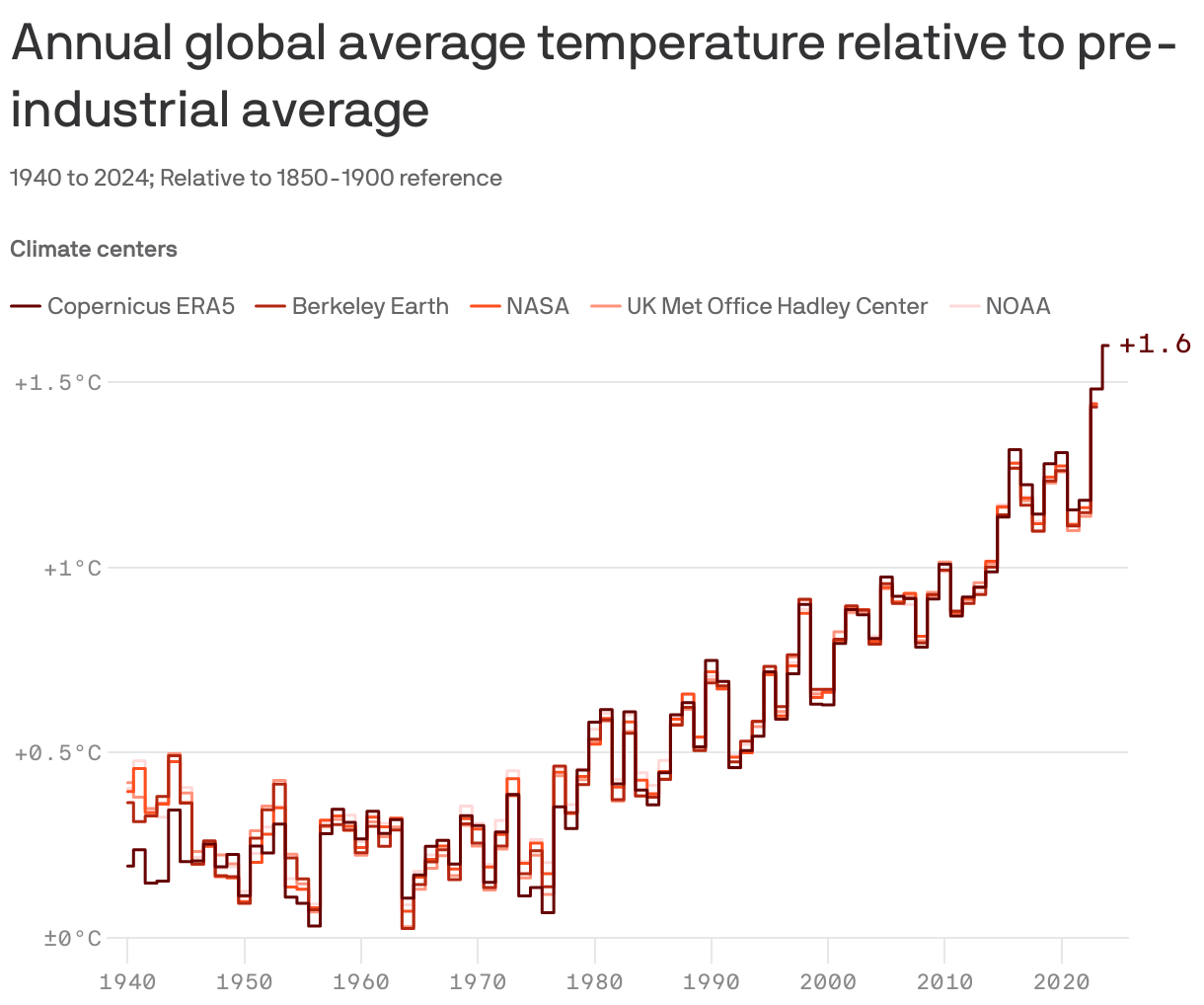
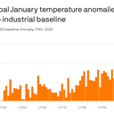
Data: Copernicus ERA5; Note: January 2025 data is preliminary; Chart: Erin Davis/Axios Visuals
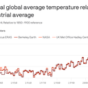
The planet just had its hottest January on record by a considerable margin, in a surprise finding (seriously) to climate scientists.
Why it matters: A La Niña event is ongoing in the tropical Pacific Ocean, which would typically be expected to cool the globe slightly. Yet that doesn't appear to be the case — at least not yet.
Zoom in: That the opposite is occurring suggests either a fluke or — combined with the record hot conditions in 2023 and again last year — something more mysterious.
Climate scientists are still investigating multiple factors that may be causing the climate to warm at a faster rate than in other recent years, from changes in marine shipping fuels to the massive eruption of an undersea volcano.
So far, there's been no way to explain the 2023 and 2024 records, but the expectation is that this year will be a top 5 hottest year — just not first place.
Yes, but: February appears poised for unusually cold temperatures across much of the Northern Hemisphere, which should lower global temperatures somewhat, according to climate scientist Zeke Hausfather, writing on Substack.
What they're saying: "An unexpected record to start things off may presage higher temperatures this year than many of us thought," Hausfather wrote.
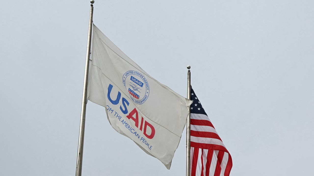
The US Agency for International Development (USAID), which Elon Musk has vowed to "kill" with President Trump's support, could destabilize regions where human-caused climate change is hitting particularly hard.
Why it matters: By ending humanitarian assistance and proactive climate resilience and adaptation programs, the U.S. military could get pulled into responding to more future crises.
Experts tell Axios that axing the agency completely, or even significantly downsizing it, would have security implications when it comes to climate change.
Catch up fast: USAID, an independent, operational agency now potentially moving under the State Department, conducts a variety of projects in climate-vulnerable locations such as Africa, Central America and parts of Asia.
These include programs meant to help boost the resilience of agricultural production to extreme weather events and make infrastructure better able to withstand such events.
Zoom in: According to archived versions of USAID's websites, the agencyhelps countries cut their emissions, conserve carbon-rich tropical rainforests and rely more on renewable energy sources.
"Climate change affects nearly everything we do at USAID," its climate page stated as of Jan. 17, according to the Internet Wayback Machine.
"As such, the Agency mainstreams climate change considerations across much of our development and humanitarian assistance work."
What they're saying: Curtailing USAID is "going to add substantially to the instability in these volatile regions, because vulnerable populations will be doing without," Sherri Goodman, a senior fellow at the Wilson Center and board chair at the Council on Strategic Risks, told Axios.
"Instability morphs, as we've seen in certain regions where insufficient governance, you don't have access to the basics, and there's a vacuum created and that also allows for other malign actors to come in," she said.
She said it's a choice between paying "a little bit now" to help make regions "more resilient to food and drought shocks, or pay more later by having to send American sons and daughters into conflict areas."
A pullback in foreign aid could also benefit China, which may step into the void to offer its aid and earn more favor in Africa and elsewhere, Goodman and others said.
"Trump's decision to shut down USAID has frozen critical work to deliver vital assistance around the globe, and put China in the driver's seat," Sen. Chris Van Hollen (D-Md.) tweeted.
By being proactive with aid and on-the-ground programs, USAID provides the U.S. with a way to head off future crises before they get to that point.
For example, USAID, along with other agencies, operate a famine early-warning system to predict them before they occur, and direct aid to where it is needed most.
The agencies also distribute food aid from U.S. farmers to those who need it most, which can cut down on migration that could destabilize countries or send waves of immigrants to the U.S.
What's next: It's currently unclear what USAID's fate will be given Musk's intense focus on it in recent days and Secretary of State Marco Rubio's statement that he is now the acting USAID administrator.
Sen. Brian Schatz (D-Hawaii) is placing a "blanket hold" on Trump's State Department nominees in response to USAID actions, the WSJ reports.
A novel new report combining several strands of research finds that human-driven climate change could result in $1.47 trillion in net property value losses from rising insurance costs and shifting consumer demand.
Why it matters: Insurance costs are increasing faster than mortgage payments. That's squeezing homeowners and leading to climate change-driven migration away from high-risk areas in the Sun Belt and the West.
The report from First Street, a climate risk financial modeling company, identifies the five largest metro areas likely to see the biggest spikes in insurance premiums: Miami, Jacksonville, Tampa, New Orleans and Sacramento.
Zoom in: The report is based on peer-reviewed models of how climate change may affect insurance prices, migration and economic patterns, among other factors.
The findings are particularly timely given the recent, devastating wildfires in Southern California, which caused an estimated $20 to $30 billion in insured losses and raised the topic of how insurance premiums price wildfire risks.
According to the new research, climate impacts may disrupt historical migration to Sun Belt states as risks of climate change-worsened extreme weather events continue to grow.
First Street estimates that unrestricted, risk-based insurance pricing would yield a 29.4% increase in average insurance premiums across the country by 2055.
This would include an 18.4% correction for "current underpricing" and an 11% increase from climate risk increases.
The intrigue: The economic, climate and demographic modeling behind this report predicts that more than 55 million Americans will "voluntarily relocate within the U.S. to areas less vulnerable to climate risks by 2055."
This would include 5.2 million internal climate migrants in 2025.
Economic growth has been thought of as a shield of sorts to retain population in areas that suffer from increasingly severe climate change-related disruptions.
In its analysis, First Street warns that may not hold up through 2055,with some metropolitan areas crossing "tipping points" in which they begin to see net declines in population.
Already, researchers found that fast-growing cities in the South, Southeast and West have pockets of higher climate risks where homes are gaining value more slowly than similar homes in less risky areas.
There may be winners, however, with northern, currently less-populated areas from Montana to Wisconsin — and in parts of the East — taking in more people because of the region's greater climate resilience.
Between the lines: First Street's report itself hasn't been peer-reviewed, and there are important caveats and uncertainties associated with the work, since it combines results from multiple models and peer-reviewed studies.
Jeremy Porter, head of climate implications for First Street and a demographer by training, laid out to Axios via email the new research's usefulness as well as its limitations.
He said the models don't account for climate adaptation measures such as stricter building codes and sea walls to shield coastal areas from storm surge flooding.
They also don't include inflation, which could miss non-climate-related housing market appreciation, along with other market forces that could also run counter to climate-risk-related losses in value.
The bottom line: These results are best used to identify locations that are most at risk for climate change-related increasing insurance costs, property devaluation and population change, Porter said.
A move by Allen Media Group to centralize weather operations at the Weather Channel, rather than keeping meteorologists at its local stations, has met with fierce resistance from viewers.
Why it matters: Local meteorologistsknow the communities they serve, and viewers tend to trust them over national sources. In severe weather situations, those factors can save lives.
Many broadcasters also are trusted messengers on climate change.
Zoom in: Allen Media Group, owned by billionaire Byron Allen, owns both the Atlanta-based Weather Channel and a slew of local TV stations, mainly in smaller media markets.
These range from KITV and KIKU in Honolulu to WCOV in Montgomery, Ala.
The company announced a plan on Jan. 18 to use its state-of-the-art studios in Atlanta and move some of its local meteorologists there, while leaning on the Weather Channel's resources and personnel as well.
The plan — set to play out during 2025 — also involves letting go of some local TV forecasters, prompting a wave of meteorologists to post online looking for new job opportunities and at least one to tell viewers goodbye during a newscast.
The intrigue: In some of these TV markets, losing local meteorologists could create a TV weather desert in much the same way that losing newspapers nationwide has led to news deserts.
Some in the TV weather industry fear that the Allen Media move represents a coming consolidation of local meteorologists to centralized weather hubs, given that just a few companies own a large number of local stations.
Friction point: Viewer reactions to the planned changes has illustrated the bond between local meteorologists and their viewers.
WTVA in Tupelo, Miss., was among the stations where the weather was reportedly set to be outsourced to Atlanta, prompting viewers to organize a petition to save the meteorology team's jobs.
Six state senators also drafted a resolution to urge Allen Media to reconsider layoffs.
When an EF-3 tornado struck Amory, Miss., in March 2023, the forecast and warning from WTVA's Chief Meteorologist Matt Laubhan saved lives, Amory resident Jenny Hutson told Axios.
Hutson's home was severely damaged in the tornado, but her family took refuge in a community shelter thanks to Laubhan's guidance about exactly where the storm was headed.
Laubhan also went viral during his forecast for that storm when he briefly prayed for the city live on television.
"I just was just so thankful that he took the time to pray over people he doesn't personally know. …. That will always mean something to me," she said.
The other side: According to a person closely familiar with Allen Media's strategy, it stems from recognizing that extreme weather events are becoming more severe and frequent, largely because of climate change.
As a result, how TV weather is presented needs to change, and the company's state-of-the-art weather production facilities in Atlanta offer significant advantages for their local stations to tap into, the person said.
The Weather Channel's studios boast advanced immersive media production capabilities that can show viewers the effects of everything from storm surge flooding to an EF-5 tornado.
Allen Media intends to take the next year to implement its plan, with some of its local TV meteorologists already interviewing and being offered jobs in Atlanta.
Others may stay at their stations, and some may lose their jobs.
State of play: Matt Chisolm, another WTVA viewer, told Axios he is concerned about the impact that outsourcing weather forecasts will have on an area that's notorious for tornadoes and severe weather.
That's especially true, he said, when many residents don't have storm shelters in their homes and rely on advance warnings to have time to get to a community shelter.
Chisholm, a self-proclaimed weather geek, said when forecasters use local landmarks, schools or churches to give you a storm's path, "it feels more real."
"It's just the way people think, and they're going to be more apt to take heed of the warning," he said. Forecasters in Atlanta can't possibly know local landmarks and backroads in rural areas, he added.
The bottom line: Given climate change-related extreme weather trends, the push to broadcast local weathercasts from Atlanta strikes many as ill-suited to keeping people safe.
It is also a warning sign of the future for TV meteorology.
Why it matters: The study — from an international group of 32 climate researchers — shows how climate change fits into the myriad factors that made the multiple blazes one of California's most destructive and expensive wildfire disasters on record.
"Overall the paper finds that climate change has made the Los Angeles fires more likely despite some statistical uncertainty," said Gabi Hegerl, a climate scientist at the University of Edinburgh who wasn't involved in the study, in a statement.
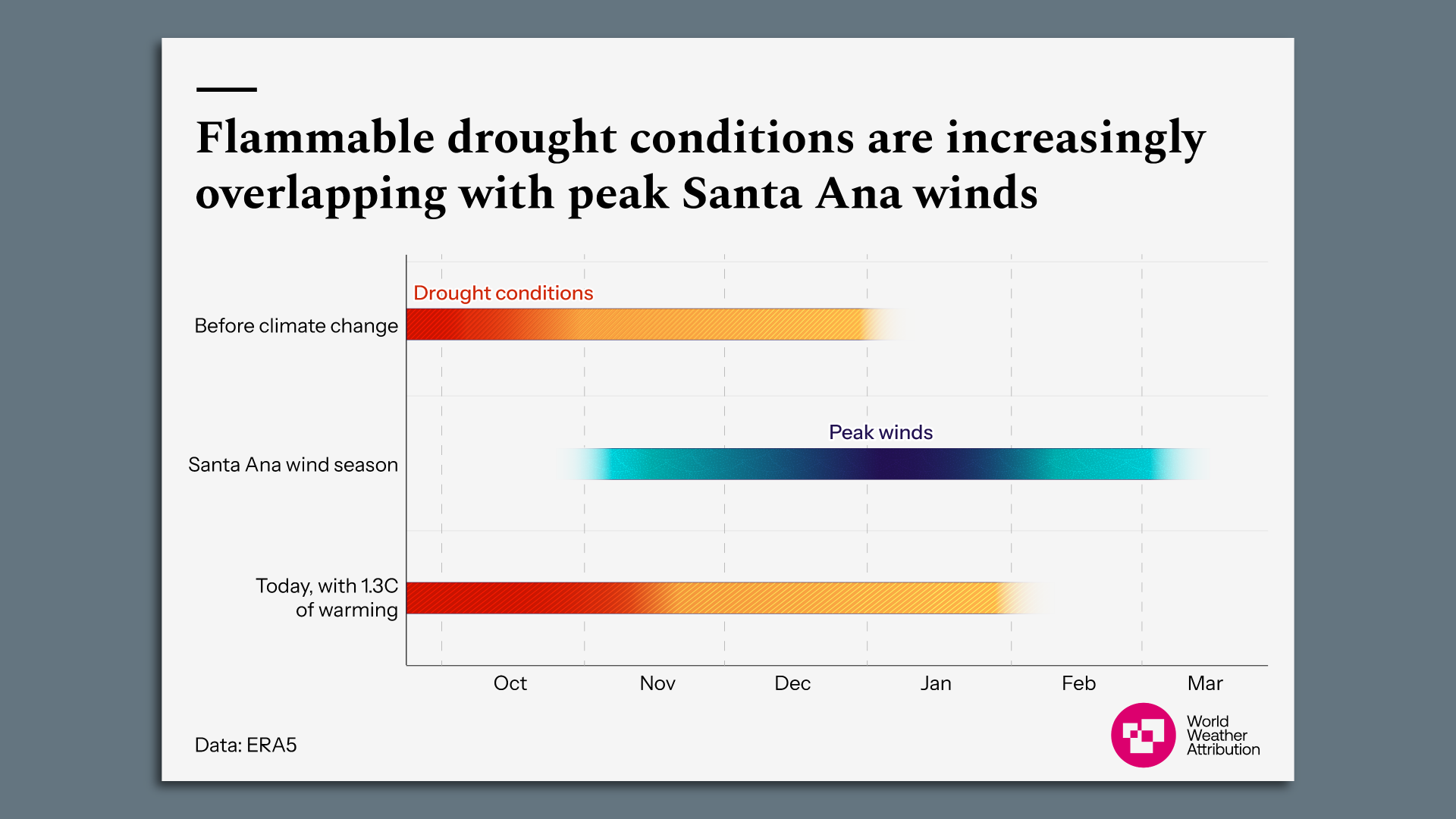
Zoom in: In making their conclusions, World Weather Attribution researchers zeroed in on the high winds; weather whiplash from unusually wet to extremely dry conditions preceding the fires; and long-term trends.
The scientists found that low rainfall from October through December is now more than twice as likely compared to the climate that existed before humans began burning fossil fuels such as oil, coal and gas for energy.
But they didn't conclusively tie this to climate change.
They also concluded that the LA fire season is becoming longer, with "highly flammable drought conditions" lasting about 23 more days now than during the preindustrial era.
This makes for greater overlap between warm and dry conditions and strong Santa Ana offshore winds that can cause fires to spread quickly.
Chart showing the increasing overlap between drought conditions and peak Santa Ana wind season. Image: World Weather Attribution
Zoom out: The study isn't the last word on this topic, nor does it come without uncertainties. But its findings are in line with other research.
By the numbers: According to the study, the hot, dry and windy conditions that propelled the flames into communities such as Altadena and Pacific Palisades were about 35%, or 1.35 times, more likely today due to the warming from burning fossil fuels such as oil, gas and coal, when compared to the preindustrial climate.
These conditions, as measured by the Fire Weather Index, would become another 35%, or 1.8 times, more likely to occur in January if global warming reaches 2.6°C (4.68°F) above preindustrial levels.
This amount of warming is a lower bound for what is expected by the end of the century, as the world is currently on course for upwards of 3°C (5.4°F) of warming.
The Fire Weather Index takes multiple factors into account, including temperature, humidity, wind speed and the amount of preceding precipitation.
What they're saying: "Climate change set the stage, helping turn the hills around LA tinder-dry," said Roop Singh of the Red Cross Red Crescent Climate Centre in a statement.
"However, hurricane-force Santa Ana winds, the rapid spread of fires into urban zones, and a strained water system all made the blazes extremely difficult to contain," he said.
The intrigue: Climate change is also at least doublingthe chances for below-average October through December rainfall in the LA area, the researchers found,
In addition, hotter air temperatures are also making the atmosphere more efficient at evaporating moisture from the Earth's surface.
Plants dry out faster in hotter temperatures, causing them to burn more easily.
The study found a greater chance that drier, more combustible conditions will now overlap with the peak Santa Ana wind season in December and January.
Yes, but: The study based the rainfall trend analysis on both observational data and climate models. The models didn't show clear trends in rainfall or the fire season's end date — while the observational data did, and other published studies have as well.
This study, like the dozens of other climate attribution studies that come soon after an extreme weather event, has yet to undergo peer review but is based on proven methods.
How they did it: The researchers used peer-reviewed methods to examine how fire events and risk in Southern California have changed since the preindustrial era.
They conducted multiple analyses with observations and computer models.
In addition to this study'smethods, the authors took into account peer-reviewed literature showing an increasing risk of wildfires and uptick in the extent of burned land, including in the West and Southwest, as the world warms.
Between the lines: The study notes that El Niño and La Niña, two natural climate cycles in the tropical Pacific Ocean, influence Southern California's seasonal precipitation.
The bottom line: "This is a carefully researched result that should be taken seriously," Hegerl said.
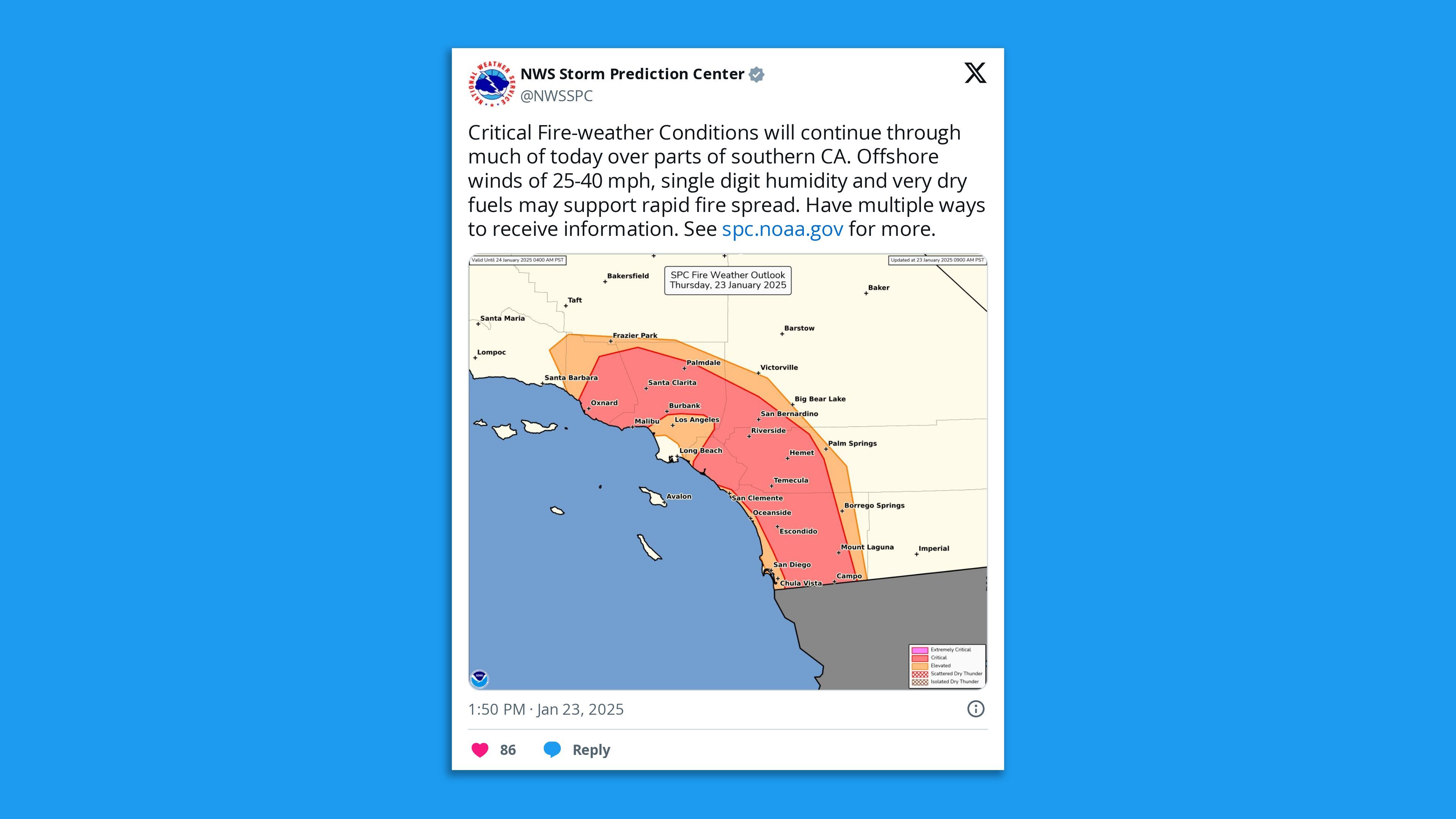
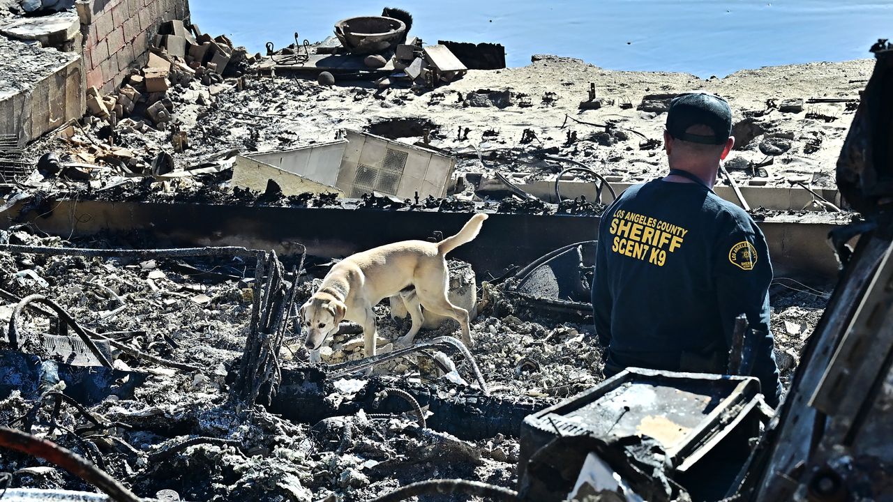
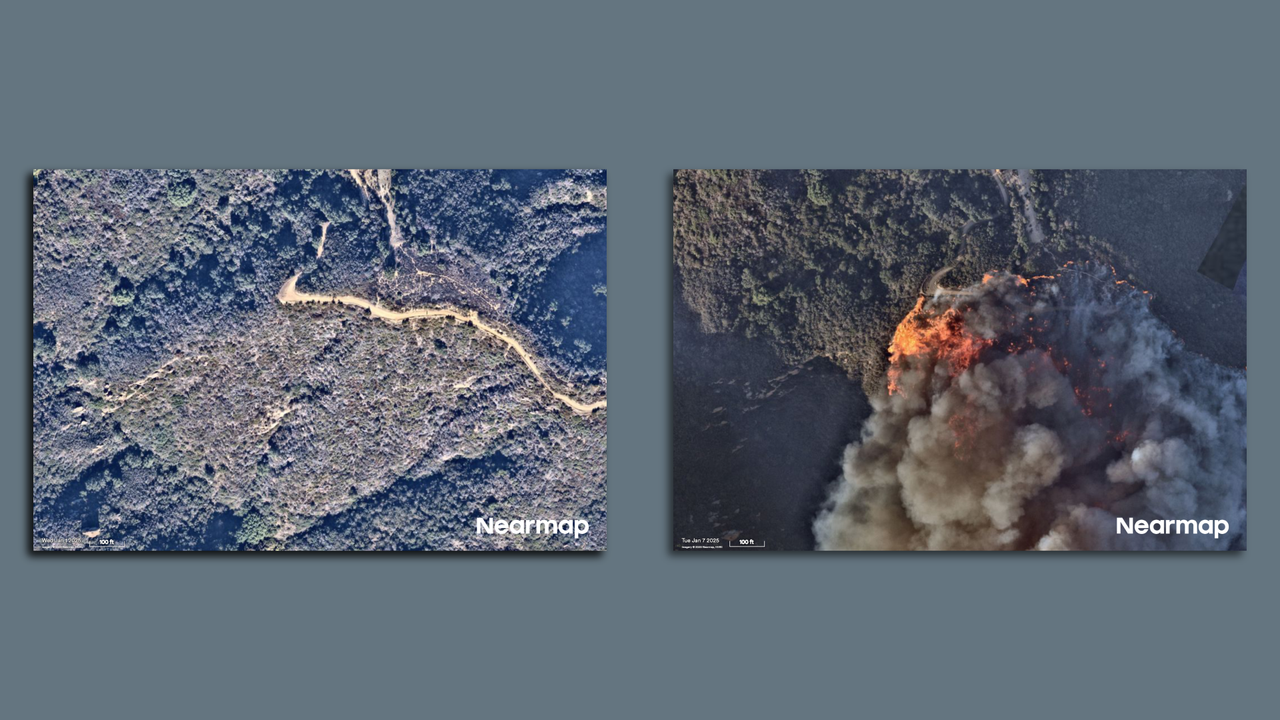
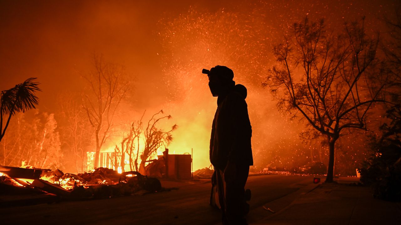
Fresh California wildfires ignited in Southern California on Thursday during "critical" fire weather, leaving tens of thousands of people under evacuation orders.
The big picture: The Hughes Fire, north of Los Angeles, and San Diego County's Border 2 Fire were among the biggest threats as the destructive Eaton and Palisades fires continued to burn during the fourth straight day of red flag warnings amid dry, windy conditions.
State of play: The Hughes Fire grew to 10,396 acres by Thursday night and was 36% contained after igniting a day earlier in Los Angeles County and spreading across over 5,000 acres to Ventura County — making it the biggest and fastest-spreading wildfire since the Eaton and Palisades fires erupted on Jan. 7.
LA County Sheriff Robert Luna said at a Wednesday briefing that some 31,000 people were under mandatory evacuation orders and a further 23,000 were under evacuation warnings in the fire that's near the popular water reservoir Castaic Lake, some 40 miles from the Palisades and Eaton fires.
The blaze in the San Gabriel Mountains prompted authorities on Wednesday to temporarily close all northbound lanes on Interstate 5 from just north of State Route 126 and issue smoke, windblown dust and ash advisories.
In San Diego County, the Border 2 Fire was burning out of control across some 600 acres after exploding in size following its ignition about 2:30pm Thursday.
The county has seen at least seven fires this week, some of which prompted since-lifted evacuation orders. However, Axios San Diego's Kate Murphy notes this blaze is by far the biggest.
Zoom in: Other wildfires that started on Thursday included the Sepulveda Fire, which triggered evacuation warnings after igniting around 12:30am near LA's Getty Center and the UCLA campus.
The warnings were later lifted as firefighters managed to get the blaze to 60% containment over 45 acres despite facing dry, warm and gusty conditions from Santa Ana winds.
The Laguna Fire ignited in Ventura County later Thursday morning and was at 70% containment over 94 acres.
Between the lines: This extreme weather event is partly related to the Arctic blast that's been impacting most of the Lower 48 states, with cold air surging into the Great Basin helping to fuel dry, offshore winds across Southern California.
The region is suffering from hydroclimate whiplash worsened by human-caused climate change, having seen two wet winters followed by a bone-dry, unusually hot spring, summer and fall.
Many parts of Southern California have had their driest start to the wet season on record. Only 0.16 inches of rain has fallen in LA since May 6.
Much of the region has been experiencing "moderate drought" conditions, per the U.S. Drought Monitor.
What's next: A cooling trend was expected to begin on Friday and "turn significantly cooler over the weekend as a cold storm system moves over the region," per an NWS LA forecast discussion.
LA County on X urged residents to "prepare for potential flooding, mudslides & debris run-off" over the weekend due to "an increased chance of mud & debris flow in recent burn areas."
A once-in-a-generation snowstorm, tied to the polar vortex event across the Lower 48 states, is plastering the Gulf Coast with record-setting snow and ice on Tuesday.
Why it matters: This region isn't equipped to cope with heavy snow, particularly when it is accompanied by continued cold following the storm.
Situational awareness: At least 10 deaths have been reported in this rare winter storm.
Threat level: About 3 to 5 inches of snow fell in the Houston metropolitan area, and both the city's major airports shut down for the storm, as did city schools.
The National Weather Service forecast office in Houston-Galveston on Monday night described the storm as a "generational event" that is likely to eclipse the city's second-largest snowstorm on record.
The snow is moving east Tuesday, and is affecting coastal areas all the way to the Florida Panhandle and southern Carolinas.
New Orleans is also seeing its all-time snowiest day based on modern records taken at their current location. A whopping 10 inches fell across the city by Tuesday night.
Blizzard-like conditions were observed in the New Orleans metro area, with high winds and visibility down to a quarter-mile at times.
Snowfall reports ranged from about 5 inches just outside the city to as much as 9 inches already in Lafayette, with snowfall rates of at least an inch-per-hour at times.
This storm could shut down road and air travel along the coastal stretch from Houston to the Florida Panhandle for days due to the lack of snow plowing equipment and the region's inexperience with these winter hazards.
Any power outages or other cuts to basic services from the extreme cold and snow could also take days to restore.
Stunning stat: The snow that has fallen so far in New Orleans exceeds the January snowfall so far in the Twin Cities as well as Anchorage, Alaska.
Meanwhilein Southern California, strong offshore Santa Ana winds have prompted the highest category of red flag warnings for Tuesday.
And the Storm Prediction Center has issued an "extremely critical" fire weather outlook for parts of LA and Ventura Counties, as well as parts of San Diego County.
The threat may dissipate somewhat Tuesday afternoon local time, but more Santa Ana winds are on the horizon for later this week.
Zoom out: Both the snowstorms, as well as the serious California fire weather threat Tuesday, are tied to the polar vortex-related Arctic blast affecting the majority of the Lower 48 states.
Nearly 300 million people in the Lower 48 states were under some type of cold weather warning or advisory as of Tuesday morning.
In addition, the strip of winter storm and blizzard warnings stretching from South Texas to Jacksonville, Fla. is something rarely seen, as a low pressure area traverses the central Gulf of Mexico, directing abundant moisture northward, into the frigid air mass.
Why it matters: The world is a very different place today than in 2017, when Trump first moved to have the U.S. depart from the then-nascent agreement.
There may be sufficient momentum now in both the Paris regime as well as the burgeoning clean energy sector that this will make only a symbolic difference.
Zoom in: To have the U.S., which is the second-largest emitter behind China, exit the agreement even temporarily has the potential for other countries to start viewing the U.S. as an unreliable partner on climate and potentially other issues as well.
Last time the U.S. left, no other country followed that move. This time could be different, given the rightward, anti-climate policies tilt in some key countries.
However, the move also comes when clean energy innovation and deployment have hit new highs.
Between the lines: America's withdrawal from Paris doesn't take effect immediately, although the executive order notes the administration will treat it as such.
The executive order was written to be far-reaching, cutting off funding for the UN climate organization that oversees annual climate summits and facilitates activities under Paris and other climate agreements since 1992.
It would also squelch American contributions to international climate financing that would help countries adapt to climate impacts and boost clean energy production.
To become official, it takes one year after U.S. diplomats submit a document to the UN climate bureaucracy notifying them of an intent to withdraw (last time Trump withdrew, it took longer due to a feature in the then-young agreement's provisions.)
There are outstanding questions of whether the Trump administration will continue to send some representatives to the annual climate summits, as it did during his first term, or skip entirely.
The main beneficiary of a U.S. withdrawal and pro-fossil fuels policies domestically could be China, which already leads the U.S. in the clean tech space.
If the U.S.'s step back from international climate engagement results in a slower decline in global emissions, it would mean even worse climate impacts.
It would also ensure that the agreement's 2°C target, which many experts say is still feasible with rapid emissions cuts, could slip.
What they're saying: "There is no sugar-coating this — it will be harmful to global efforts to combat climate change, and so ultimately, also harmful to the future prosperity and security of U.S. citizens," said Kaveh Guilanpour of the Center for Climate and Energy Solutions, in a statement.
He noted, though, that the world has been here before, and the agreement survived.
Why it matters: The moves amount to policy whiplash for the energy industry, segments of which had chafed under former President Biden's policies aimed at igniting the renewable sector.
Zoom in: The executive orders include a declaration of a "national energy emergency" aimed at increasing domestic energy production and lowering costs to the consumer.
This is partly in response to the rapid AI-related growth of data centers and their energy needs, which the administration views through a national security lens.
U.S. power demand is rising quickly after staying largely flat for the last 15 years.
One of Trump's initial orders formally rescinds a series of Biden moves that stitched climate and environmental justice throughout federal agency decision-making, going well beyond energy and resource agencies.
This includes a repeal of the Biden administration's Justice 40 Initiative and a 2021 order that set aggressive federal procurement targets for EVs, clean power, low-carbon buildings and more.
Trump also moved ahead with rolling back EPA tailpipe emissions rules that Republicans have characterized as an effective requirement for consumers to buy electric vehicles.
He also signed an order that attempts to rescind Biden's formal withdrawal of East Coast, West Coast and major offshore Alaskan Arctic areas from drilling.
But there's no guarantee producers have much appetite for exploring these regions, and formally selling drilling rights and enabling development would be a complicated bureaucratic and litigious process.
Other actions include seeking to pause funds from being spent under the Biden climate law, and shifting appliance energy efficiency standards back to Trump's first term, before Biden made them more stringent.
Threat level: Trump's attempted reversal of Biden-era policies could boost U.S. greenhouse gas emissions — or at least slow down projected reductions.
Reality check: Trump's "dominance" agenda will also confront market and process barriers — and plenty of litigation.
U.S. oil output is already at record levels. Tepid global demand growth makes producers in Texas and elsewhere unlikely to flood the market.
Gasoline and diesel costs are tethered to oil prices set on global markets, while electricity costs tend to be highly regional and dependent on weather and other forces.
Executive orders can make some instant policy. Often they're a symbolic opening of the long, legally fraught bureaucratic slog of formally unwinding agency rules and policies.
Between the lines: Presidents can use emergency authorities to redirect resources and push the private sector to boost or maintain critical supplies.
However, it's likely that the declaration itself will be challenged in court. And its provisions are likely to run into thorny legal issues given that state and regional authorities typically oversee power plant planning and permitting.
The good news for those companies extends beyond the energy orders.
Trump's holding off for now on sweeping new tariffs that execs fear could raise project costs — and spur retaliation from buyers of U.S. exports.
But it may be a temporary reprieve, with Trump instead ordering reviews of trade and currency imbalances.
What they're saying: "By fully harnessing our nation's abundant oil and natural gas resources, we can restore American energy dominance, drive economic prosperity and secure U.S. leadership on the global stage," Mike Sommers, president and CEO of the American Petroleum Institute, said in a statement.
But Tiernan Sittenfeld of the League of Conservation Voters said in a separate statement: "It is crystal clear that his administration is all in to pad Big Oil Billionaire profits at the expense of our air, water, lands, climate, health, pocketbooks, and jobs."
The bottom line: The energy-related executive orders will yield some short-term actions on the ground.
But it's their longer, topsy-turvy road to implementation that will be crucial to accomplishing the administration's goals.
President Trump signed an executive order during his first hours in office to begin the process of pulling the U.S. out of the Paris Climate Agreement — the second time he has done so.
Another U.S. departure from the pact would leave a major hole in international efforts to curtail greenhouse gas emissions and potentially call the country's foreign policy credibility into question.
Zoom in: It takes a year for a country to withdraw from the agreement.
The Paris Agreement doesn't require countries to cut their emissions, but works through international peer pressure and countries' domestic laws to encourage nations to set ambitious emissions reduction targets.
Prior to signing the order, the incoming Trump administration described this and other actions on energy as a way to end former Biden's "climate extremism."
Flashback: The U.S. has been here before. Trump pulled the country out of Paris during his first term, only to have former President Biden rejoin the pact on his first day.
Then, no other country followed the U.S. move to leave the agreement. The U.N. says 194 nations plus the European Union have joined the pact.
Also, the first Trump administration continued to send representatives to the annual climate summits.
Between the lines: Leaving Paris again could cement foreign diplomats' and observers' view of the U.S. as an unreliable partner, given the U-turn from Biden's climate policies.
Trump and his nominees have promised to increase fossil fuel production, roll back climate programs that the Biden administration had put in place, and unleash a broad policy of "energy dominance."
In addition to the Paris Agreement executive order, Trump signed multiple energy orders that would — if implemented — reorient the U.S. away from a focus on lowering greenhouse gas emissions, and toward increasing oil and gas production and boosting available electricity on the grid.
The intrigue: Trump has long characterized the agreement as putting too much burden on the U.S. compared to other countries.
"The United States will not sabotage our own industries, while China pollutes with impunity," Trump said Monday night before signing the executive order.
Reality check: Right now, greenhouse gas emissions are still too high to meet the agreement's temperature targets, even though some country's, including the U.S., have been reducing their emissions.
If a U.S. departure were to slow the decline in domestic emissions and cause other countries to balk at taking more aggressive efforts, then it may make it even harder for the targets to be met.
The action on Paris comes amid an increase in the severity and frequency of certain extreme weather events, and a little more than a week after climate change-worsened wildfires tore through metro LA, killing at least 27 and destroying more than 10,000 homes.
What they're saying: "By leaving the Paris Agreement, this administration has abdicated its responsibility to protect the American people and our national security," said Gina McCarthy, former White House national climate adviser and now managing co-chair of the "America is All In" coalition.
"The U.S. withdrawing from the Paris Agreement is unfortunate, but multilateral climate action has proven resilient and is stronger than any single country's politics and policies," said Laurence Tubiana, a key architect of the Paris Agreement, in a statement.
Simon Stiell, the top UN climate diplomat, issued a statement saying any country is welcome to offer "constructive engagement" at future climate talks.
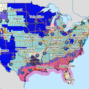
An invasion of frigid air from the Arctic is sweeping south from the Plains and Ohio Valley Sunday, moving towards the Southeast and East.
Threat level: The colder-than-average temperatures threatens public health for those exposed to the wind and cold, and may harm water and power infrastructure from North Dakota to Texas, on eastward.
The extreme cold has links to the polar vortex, which is a feature of the winter climate during winter in the Northern Hemisphere.
"Life-threatening" wind chills down to minus-55°F are likely in the Plains and Upper Midwest, the NWS warns, mentioning the risk of hypothermia and frostbite for people exposed to the cold for too long.
Sub-zero wind chills are forecast to affect the Ohio and Tennessee Valley Sunday night through midweek, with the possibility of similar cold spreading into portions of the Mid-Atlantic and Northeast in the wake of a winter storm.
Along with the cold, a snowstorm is affecting areas from the Mid-Atlantic to the Northeast on Sunday into Monday. It is poised to potentially become the heaviest snowstorm so far this year for Philadelphia, New York City and Boston, with 5 to 10 inches possible in this broad region.
What they're saying: "This will be the coldest air of the winter season thus far, and in many cases the coldest in several years," the NWS warns.
Zoom in: The hazardous cold will be especially disruptive in the South and Southeast, where temperature departures from average will be significant and persistent.
A rare winter storm is set to deliver a severe snow and ice storm from Houston to Baton Rouge and New Orleans, eastward towards the Carolinas beginning Monday.
As of Sunday morning, the National Weather Service was calling for about 3 inches of snow to fall in Houston, with up to 5 inches in parts of the metro area.
About 2 to 3 inches of snow are expected to fall in New Orleans, with 4 to 6 inches in Baton Rouge.
The intrigue: The NWS forecast office in New Orleans is urging residents to "Exercise extreme caution if travel cannot be avoided" due to the cold and snow that is expected.
"Given the rare southerly track of this winter storm, major traffic and travel disruptions are likely through mid-week," the NWS stated in an online forecast discussion.
By the numbers: Here's how some cities will be affected early next week:
Minneapolis: A high of minus-5°F with a low of minus-13°F on Jan. 22.
Denver: A high of 6°F and a low of minus-4°F on Jan. 20.
Dallas: A high of 33°F and a low of 23°F on Jan. 21.
New York City: A high of 18°F and a low of 10°F on Jan. 21.
Washington, D.C.: A high of 21°F and a low of 11°F on Jan. 21.
The intrigue: The cold air may also spill westward into the Great Basin, setting up yet another period of strong, offshore Santa Ana winds in Southern California.
The Storm Prediction Center has issued a rare, "extremely critical" wildfire risk outlook for Monday across some of the same areas hit by the devastating wildfires earlier this month.
Zoom out: The factors behind this cold outbreak include a strong high pressure area or "ridge" in the jet stream across the eastern Pacific north to Alaska. Meanwhile, there's a dip, or "trough," in the jet stream across central portions of the U.S.
It is expanding southward and helping to promote the flow of air from northern Canada southward toward the continental U.S., said Judah Cohen, a meteorologist at Atmospheric & Environmental Research.
Zoom out: The polar vortex in the stratosphere is altering the jet stream one atmospheric layer down, in the troposphere. This is where most weather takes place.
A powerful Arctic outbreak tied in part to the polar vortex is set to send temperatures by next week tumbling down to as cold as 25 to 35 degrees Fahrenheit below average for mid-January, forecasts show.
Why it matters: The hazardous cold could endanger public health, stress electricity grids, damage crops and make for a frigid Inauguration Day.
This event is likely to be far colder and more widespread than the Arctic outbreak that occurred earlier this month.
Threat level: Mother Nature's refrigerator door looks to open, with cold air spilling southward out of northern Canada beginning Friday night and lasting for at least a week.
Through Sunday, about 81 million people are predicted to see temperatures plunge to below-zero Fahrenheit, and the number affected will increase from there.
That's a smaller number compared with the polar vortex winter of 2013-2014. But it will increase after Sunday.
"Dangerously cold wind chills" are likely in the Plains and Upper Midwest, the NWS warns, mentioning the risk of hypothermia and frostbite for people exposed to the cold for too long.
Zoom in: The hazardous cold will be especially disruptive in the South and Southeast, where temperature departures from average will be significant.
The region also may see a snow and ice storm midweek next week.
The Arctic outbreak is likely to result in a blustery and frigid Inauguration Day, with temperatures in the mid-20s°F and wind chills in the teens on the National Mall when President-elect Trump takes the oath of office.
By the numbers: Here's how some cities may be affected early next week:
Minneapolis: A high of minus-6°F with a low of minus-14°F on Jan. 20.
Denver: A high of 7°F and a low of minus-5°F on Jan. 20.
Dallas: A high of 34°F and a low of 21°F on Jan. 20.
Washington, D.C.: A high of 26°F and a low of 20°F on Jan. 20.
Between the lines: The factors behind this cold outbreak include a strong high pressure area or "ridge" in the jet stream across the eastern Pacific north to Alaska. Meanwhile, there's a dip, or "trough," in the jet stream across central portions of the U.S.
This will allow Arctic air to surge southward, Zack Taylor, a forecaster at NOAA's Weather Prediction Center in College Park, Md., told Axios.
There's also a connection to the tropospheric polar vortex, which is distinct from the higher-level, stratospheric polar vortex.
The latter feature of the Northern Hemisphere winter climate is currently becoming "stretched" from north to south across the North Pole, but it is not breaking into pieces and surging towards the Lower 48 states as it did in 2014.
Instead, the stretched vortex is expanding southward and helping to promote the flow of air from northern Canada southward toward the continental U.S., said Judah Cohen, a meteorologist at Atmospheric & Environmental Research.
Zoom out: In the troposphere, at about the same height that jet aircraft cruise, a lobe or multiple pieces of ultra-cold air may enter the U.S. while rotating around Hudson Bay, Canada.
These could result in some of the most extreme cold temperature anomalies of this event.
In a sign of the magnitude of the cold air on tap for the U.S., computer models are projecting a record strong area of high pressure over Missouri to form early next week, Taylor said.
Friction point: But this area of climate science is hotly contested, with new studies supporting and knocking it down appearing each year.
The intrigue: While a polar vortex event was much-advertised earlier in January, air temperatures turned out to be milder than anticipated.
That's not likely to be the case this time, however, Taylor said.
"The weather pattern just looks so much better than it did compared to a week or so ago," he said, referring to the opportunity for extreme cold.
He noted wind chills could plunge to minus-30°F to minus-40°F in the Upper Midwest and Plains, and even reach below zero in the Southern Plains, Ohio Valley, Gulf Coast and Mid-Atlantic early next week.
The cold air is likely to be persistent along the Gulf Coast, Taylor said.
It is not expected that this event will break dozens of records, in part because it can be hard to break cold temperature records at this time of year.
Why it matters: Weather forecasters are struggling with how to communicate the dangers of extreme weather events as those events increase in frequency and ferocity with human-caused climate change.
This involves a mix of meteorology and climate science, along with social science research into how people respond to warning language and official advice.
The big picture: It's unclear if the public fully grasps the meaning of the National Weather Service's fire weather warnings or the criteria behind its terms, Stephen Bieda, chief of the service's Severe, Fire, Public and Winter Weather Services Branch, told Axios.
"There is a larger-scale conversation going on" about better aligning NWS' products with input from communications and social science professionals, he said.
Zoom in: There are some eerie similarities between the firestorm that began to engulf portions of LA County on Jan. 7 and recent hurricanes — such as Ian and Helene — that were accurately forecast but still led to a large loss of life.
In the case of Ian, some late shifts in the storm's path occurred, but it remained within the so-called "cone of uncertainty." Yet many were caught off guard when a storm surge roared across Sanibel Island and into Fort Myers Beach, killing dozens.
The fires began during a period when the National Weather Service was practically screaming about the fire threat from a rare high wind event in ALL CAPS text.
The consensus was that any fire start could grow "explosively" and be nearly impossible to contain even with the pre-staging of fire crews.
Sadly, four such fires occurred around the same time, overwhelming responders, many of whom had been prepositioned to act quickly.
Context: Red flag warnings were initially created for emergency managers and land management agencies in the 1990s, Bieda said.
Similarly, "Particularly Dangerous Situation" Red Flag warnings were implemented about five years ago — again primarily for the emergency management community to increase readiness rather than the public.
But, given the accessibility of information, those warnings are widely consumed, Bieda said.
He said their basic message is that forecasters have the highest-possible confidence that a worst-case combination of dry vegetation, or fuels, and strong winds will occur to produce a potentially devastating event.
Friction point: According to Amanda Stasiewicz, a researcher at the University of Oregon, and Stephanie Hoekstra, a wildfire social scientist at CIRA and NOAA, it's one thing to tell people to be prepared for potentially dire fire weather conditions.
But pinpointing fire ignitions ahead of time isn't currently possible — and they said that may limit forecasts' utility.
"You never know where the next fire is going to break out," Hoekstra told Axios. "Something that makes fires unique is that anywhere can be ground zero."
Both Stasiewicz and Hoekstra told Axios that so-called PDS Red Flag warnings are currently only used by some NWS forecast offices, including the LA office.
They're geared mainly to partners of the NWS such as emergency management agencies and elected officials at the state, regional and local levels.
Little research has been done on how they affect public preparation and response.
Between the lines: Social scientists who study responses to extreme weather watches and warnings — as well as evacuation orders — are limited by a lack of studies on wildfires, said Julie Demuth, who studies weather risks and decisions at the National Center for Atmospheric Research.
"A major challenge we have with answering these questions is that we often don't have the social science 'observations' we need to answer these event-specific questions," she told Axios via email.
Even evidence gleaned from other fire-prone areas is relatively sparse, Demuth and other experts told Axios.
The intrigue: The NWS proactively anticipated the fire weather threat on Jan. 7, as well as the ongoing threat Tuesday through Wednesday.
The first briefing for emergency managers on the Jan. 7 fire danger took place on New Year's Day, a Weather Service spokesperson said.
The service's LA office began briefings the next day but had first mentioned the threat in its forecast products as early as Dec. 30.
Watches and warnings were hoisted beginning four days in advance of the event, NOAA's timeline states.
What's next: Its potential shortcomings aside, the Weather Service's most dire fire weather warning, the PDS Red Flag Warning, is in effect for parts of LA and Ventura Counties through Wednesday at noon.
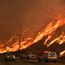
Firefighters battling the Los Angeles-area fires are facing fresh threats nearly a week after wildfires erupted across the region, fueled by powerful Santa Ana winds in extremely dry conditions.
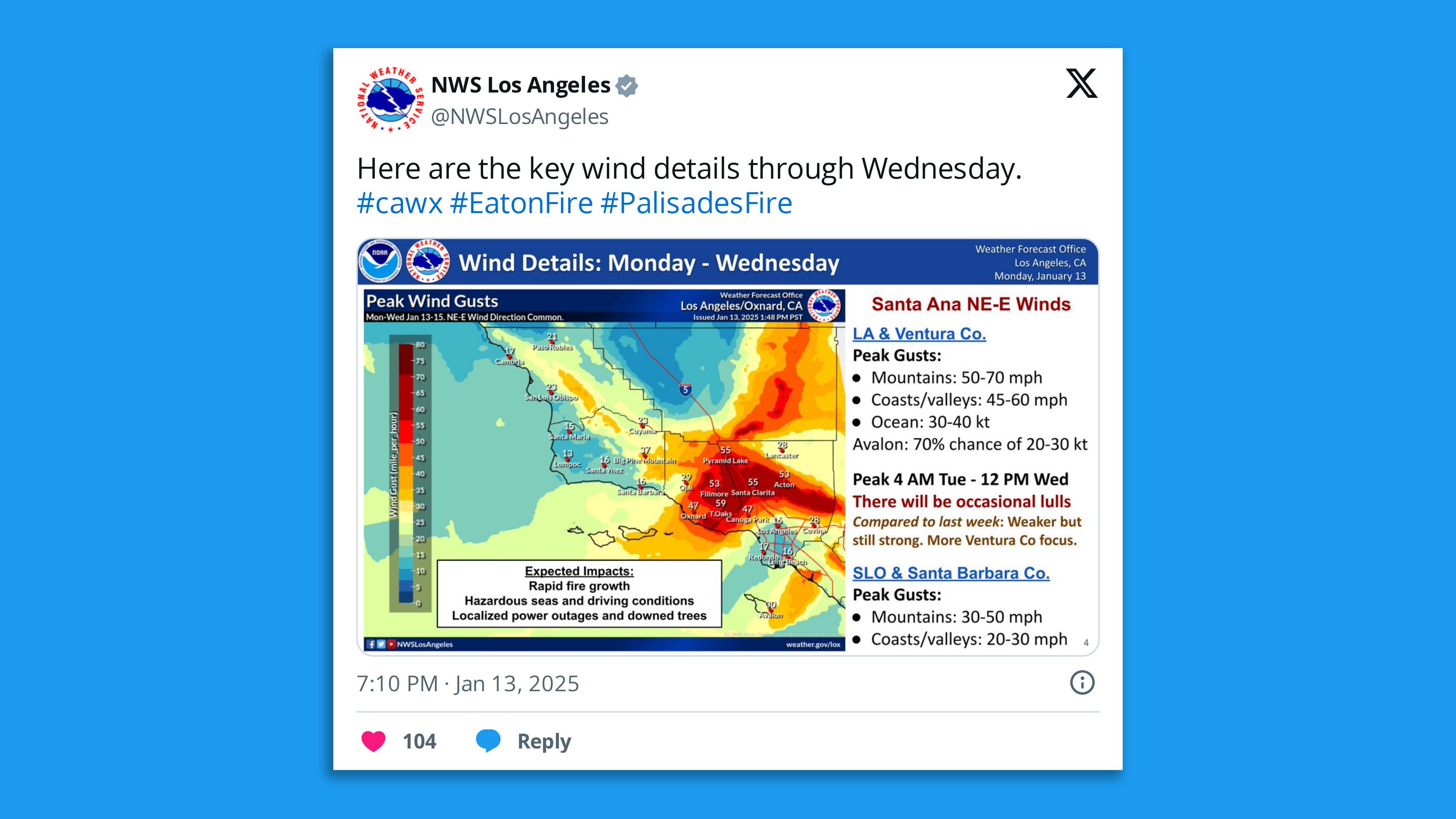
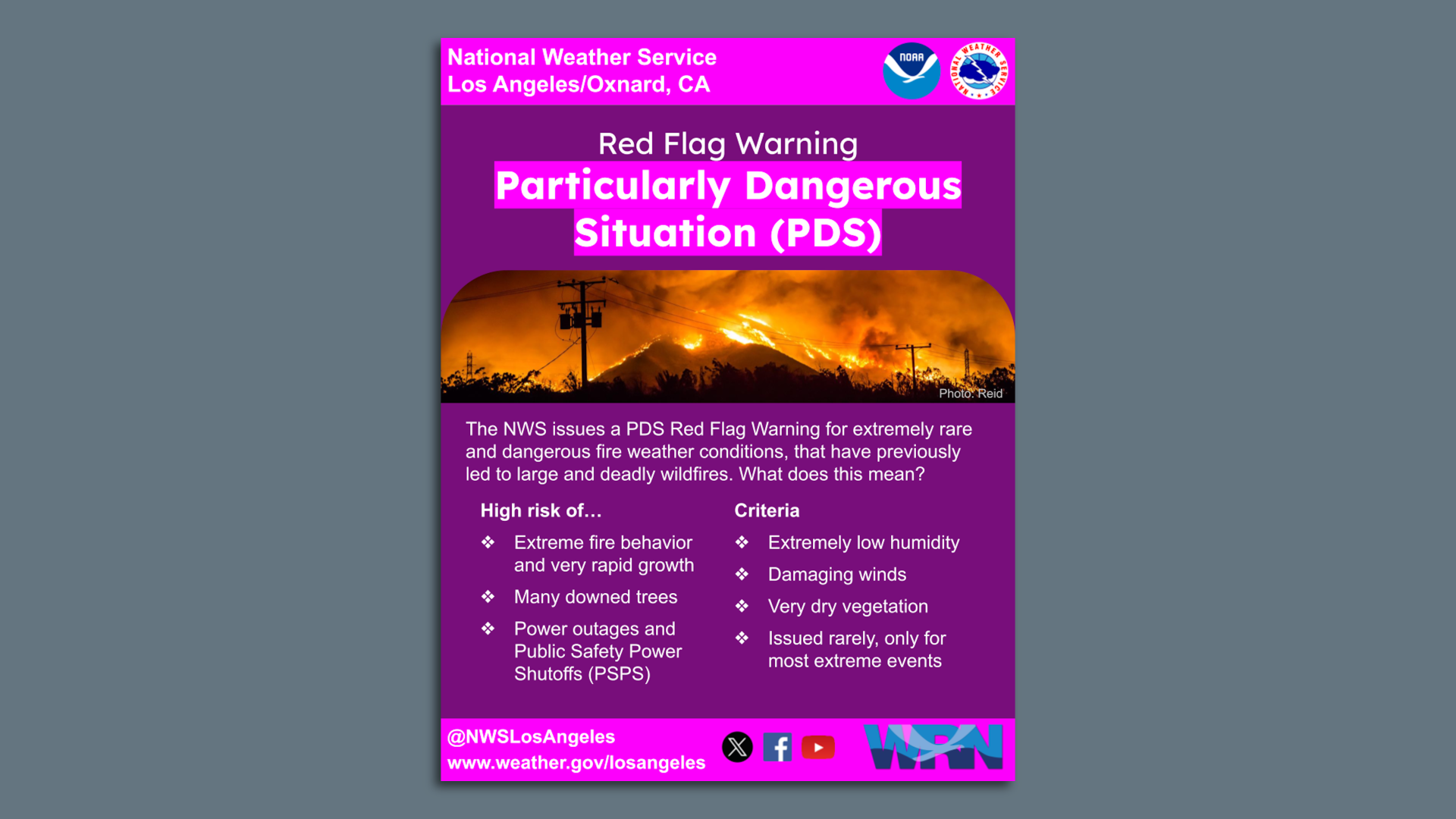
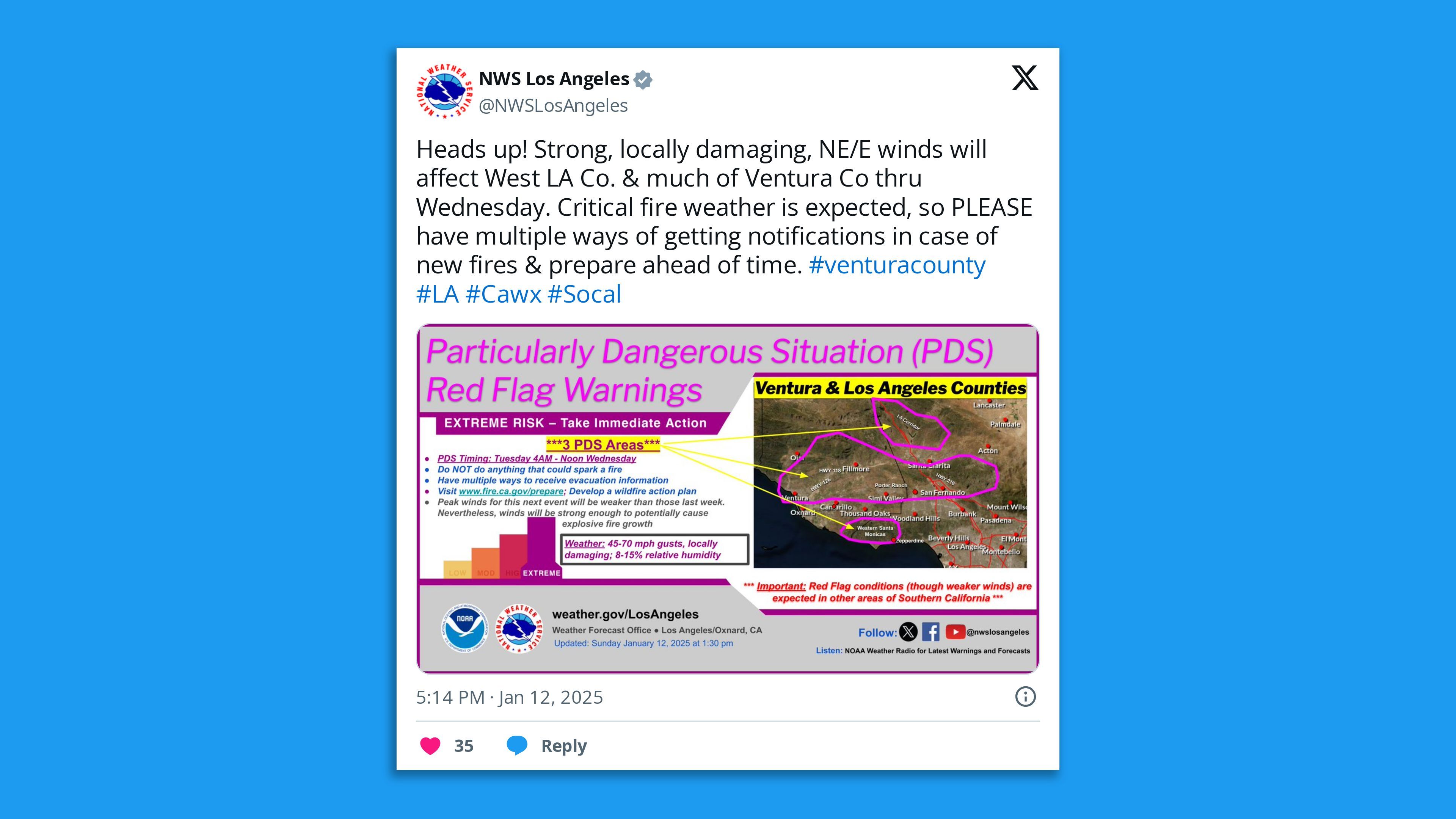
Threat level: The National Weather Service's LA forecast office Sunday evening issued a rare "Particularly Dangerous Situation" Red Flag Warning lasting until Wednesday at noon for parts of L.A. and Ventura counties, warning that high winds could cause "explosive fire growth."
Screenshot: National Weather Service Los Angeles/x
The weather service advised residents "to have multiple ways to receive evacuation information" and to "not do anything that could spark a fire."
Areas under this warning don't include the Eaton Fire but cover western Santa Monica, Simi Valley, Porter Ranch, Ventura and other parts of the hard-hit region.
Zoom in: Winds during this event will be closer to a typical strong Santa Ana, at 50 mph to 70 mph instead of up to 100 mph as seen last week.
But the east-to-west air flow will likely target areas that didn't have such strong winds last week, particularly in Ventura County.
"THIS IS A PARTICULARLY DANGEROUS SITUATION (PDS) FOR PORTIONS OF LOS ANGELES AND VENTURA COUNTIES!" the NWS said in all caps.
Much of Southern California is under some type of Red Flag Warning, with areas of "Extremely Critical" fire weather risk — the highest category from the Storm Prediction Center (SPC), from Monday through Wednesday.
Image showing the criteria for ordering a Particularly Dangerous Situation Red Flag Warning. Image: NWS
According to SPC, which issues fire weather outlooks nationally, about 740,000 people are included in the extremely critical area on Monday.
About 8.1 million are located in the "critical" fire weather risk classification, which is just below the maximum alert level.
Between the lines: According to the NWS LA office, before this season, the "PDS" classification had only been used twice before. Both were in 2020.
However, the warning type has only been in existence for about half a decade.
The product is supposed to indicate rare events, but the extraordinarily dry start to the winter wet season this year has meant that the fire season has stretched much deeper into the winter than usual.
This means it overlaps with more high wind events, which is something that climate studies show occurring with greater regularity in coming decades.
Yes, but: The Eaton and Palisades fires aren't included in the particularly dangerous situation portions of the warnings, according to the NWS, but nearby areas are and the heightened concerns relate to new fire starts as well.
Los Angeles County is facing "critical fire conditions" after firefighters have for days battled deadly wildfires that have razed entire neighborhoods, and the situation is expected to worsen this week.
Threat level: The National Weather Service issued a rare "Particularly Dangerous Situation" red flag warning that's due to start early Tuesday into Wednesday for parts of L.A. County and Ventura County, warning that winds will be high enough to cause "explosive fire growth."
The areas under this warning do not include the Eaton Fire, but do include western Santa Monica, Simi Valley, Porter Ranch, Ventura and other parts of the hard hit region.
The winds will not be as strong as the previous event but strong enough to meet the high-end criteria.
The big picture: The death toll rose to at least 24, per the L.A. County medical examiner's Sunday evening update. Another 16 people have been reported as missing, Los Angeles County Sheriff Robert Luna said during a Sunday briefing.
More than 100,000 residents remain under evacuation orders and over 12,000 structures have been destroyed.
Situation report: The Kenneth, Sunset and Lidia fires have been 100% contained,Gov. Gavin Newsom said in a Sunday update.
The Hurst Fire was at 89% containment Sunday evening, per Cal Fire.
Sixteen of the reported deaths have been attributed to the Eaton Fire, while the remaining eight have been categorized with the Palisades Fire.
Newsom announced he's deployed a further 1,000 California National Guard personnel to the Los Angeles area, taking the number assisting in firefighting efforts to 2,500.
State of play: Red flag warnings for much of Los Angeles and Ventura counties are set to remain in place until Wednesday as gusty winds and low relative humidity persist, the National Weather Service's L.A. office said Sunday evening.
NWS expects the offshore Santa Ana winds that have been making fighting the fires extremely difficult to pick back up after a brief reprieve, which could complicate firefighters' efforts to contain the flames.
Dry vegetation coupled with "prolonged extreme fire conditions" will support "rapid spread and erratic behavior" of new or existing fires, per NWS. The Eaton Fire may be less affected by strong winds than the other blazes.
By the numbers: Over 35,000 customers in Los Angeles County were without power about 12:30am Monday ET, per PowerOutage.us.
Context: Parts of Southern California are experiencing their driest start on record.
An overlap of rare climate factors is in part to blame for the rapidly spreading blazes, as the bone-dry region grapples with the worst high wind event in Southern California since 2011, per Axios' Andrew Freedman.
While the fires are not the largest wildfires the state has faced, they are among the most destructive on record.
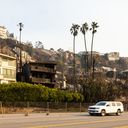
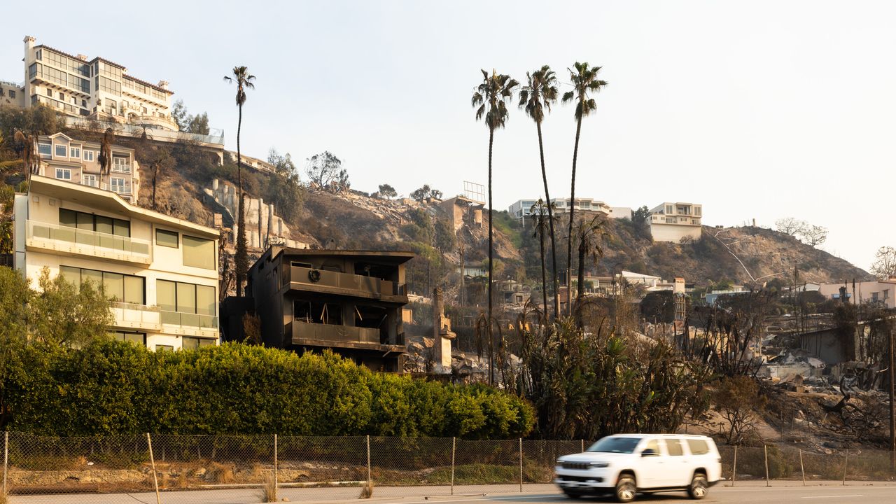
Climate change — particularly whiplash between two wet winters followed by a bone-dry, unusually hot spring, summer and fall — set the stage for Los Angeles' deadly and devastating fires, scientists say.
The firestorm was the product of what climate researchers refer to as "hydroclimate whiplash."
Other factors include one of the worst Santa Ana wind events of the past two decades; land use patterns; and sparks set off by power lines, car engines, suspected arsonists and other potential ignition sources.
Why it matters: Whatever the source, it's clear a changing climate made the fires more ferocious, long-lasting and destructive, as has been the trend across the West in recent decades.
Threat level: Though winds are no longer as strong, the overall conditions that led to the extraordinary rates of fire spread haven't abated.
That may only come with significant rainfall, which currently isn't in sight.
Zoom in: Hydroclimate whiplash occurs when one extreme precipitation regime is replaced by another.
In this case, extremely wet conditions are followed almost immediately by parched weather patterns, typically accompanied by above average temperatures.
This leads to a green up of vegetation that then dries out through evaporation, leading to ample "fuels" for a blaze to burn.
The strong winds — which reached 99 mph in some locations — acted as an "atmospheric blow dryer" on trees and other vegetation, further drying out the landscape and ensuring any fire wouldn't stay small for long, UCLA climate scientist Daniel Swain said in an online video briefing.
Stunning stat: In downtown Los Angeles, just 0.16 inches of rain has fallen since May 6, compared to the average of greater than 4 inches, per the National Weather Service.
This is the city's second-driest May 6 to Dec 31 period on record, according to the National Weather Service's Los Angeles forecast office.
No rain is in the forecast through early next week, with one Santa Ana event diminishing this morning, and another potentially strong one forecast for early in the coming week.
Zoom out: The see-saw pattern between wet and dry periods isn't new for Californians. But these swings are becoming acute — and not just in the Golden State.
A new study published last week shows these swings are becoming more of a trigger for wildfires, floods and drought globally.
In the study, scientists refer to an increasingly "expanding atmospheric sponge," since the atmosphere is able to evaporate, absorb and release 7% more water vapor for every 1°C (1.8°F) that the temperature increases.
In other words, the atmosphere gets more thirsty as the climate warms, drawing more moisture from plants, and leading to more days with extreme fire weather conditions.
This analogy captures the atmosphere's ability to absorb a larger and larger amount of water vapor as temperatures increase, and wring out more and more water due to such temperature changes.
Data shows this whiplash effect has increased by between 31% to 66% globally since the mid-20th century, and that the rate of increase is speeding up.
Between the lines: If global average temperatures increase by about 3°C (5.4°F) — which is currently likely — then the whiplash effect will more than double in its intensity.
"Increasing hydroclimate whiplash may turn out to be one of the more universal global changes on a warming Earth," Swain said in a statement.
Though the rare, powerful winds are fanning the blazes, it's the whiplash-driven lack of rain that has trapped Southern California in a seemingly never-ending fire season.
In addition to the increased thirstiness of the atmosphere and see-sawing from floods to droughts and back again, studies show that climate change is increasing the odds that windy periods occurring deeper into the traditional "rainy season" will overlap with extreme dryness.
The intrigue: Land management, the use of prescribed burns and expanding building in fire-prone areas have also contributed to this wildfire nightmare. But climate change is a large, and growing factor.
"Whether we like it or not, the nature of wildfire in Southern California is changing and we must adapt accordingly," said UCLA climate scientist Alex Hall in a statement.
"That will involve some frank conversations about the tradeoffs involved in improving our strategies to reduce ignitions, improve stewardship of our unique chaparral landscapes to reduce impacts, and protect human life and property."
The bottom line: Climate change didn't provide the spark that caused each of these catastrophic fires in LA County. But it's making such fires worse.
The National Weather Service plans to issue a red flag warning of critical fire weather conditionsincluding gusty winds and low relative humidity, effective Saturday evening through Sunday afternoon, for Los Angeles and Ventura counties, the agency's LA office stated Saturday morning.
The big picture: Historic California wildfires have severely impacted these areas, and the NWS expects offshore Santa Ana winds to pick back up, with another strong offshore event occurring early next week and no rain in sight.
Wildfires have seared more than 30,000 acres in Los Angeles County this week, leaving at least 11 people dead, per an update Friday from the Los Angeles County Department of Medical Examiner.
Threat level: With no rain in the forecast, these winds will challenge firefighters battling the ongoing blazes and any new fire starts.
Parts of Southern California are experiencing their driest start to the winter "rainy season" on record, after two wet winters encouraged plant growth that has led to ample dry vegetation for fires to burn.
What they're saying: "With continued dry conditions, Red Flag Warnings are likely. While a brief reprieve from the winds are expected Sunday Night, they will form again Monday through Wednesday, with a peak around Tuesday of gusts between 40 and 60 mph," the NWS said.
"With humidities plummeting to 5 to 15 percent, there is a high risk for Red Flag Warnings."
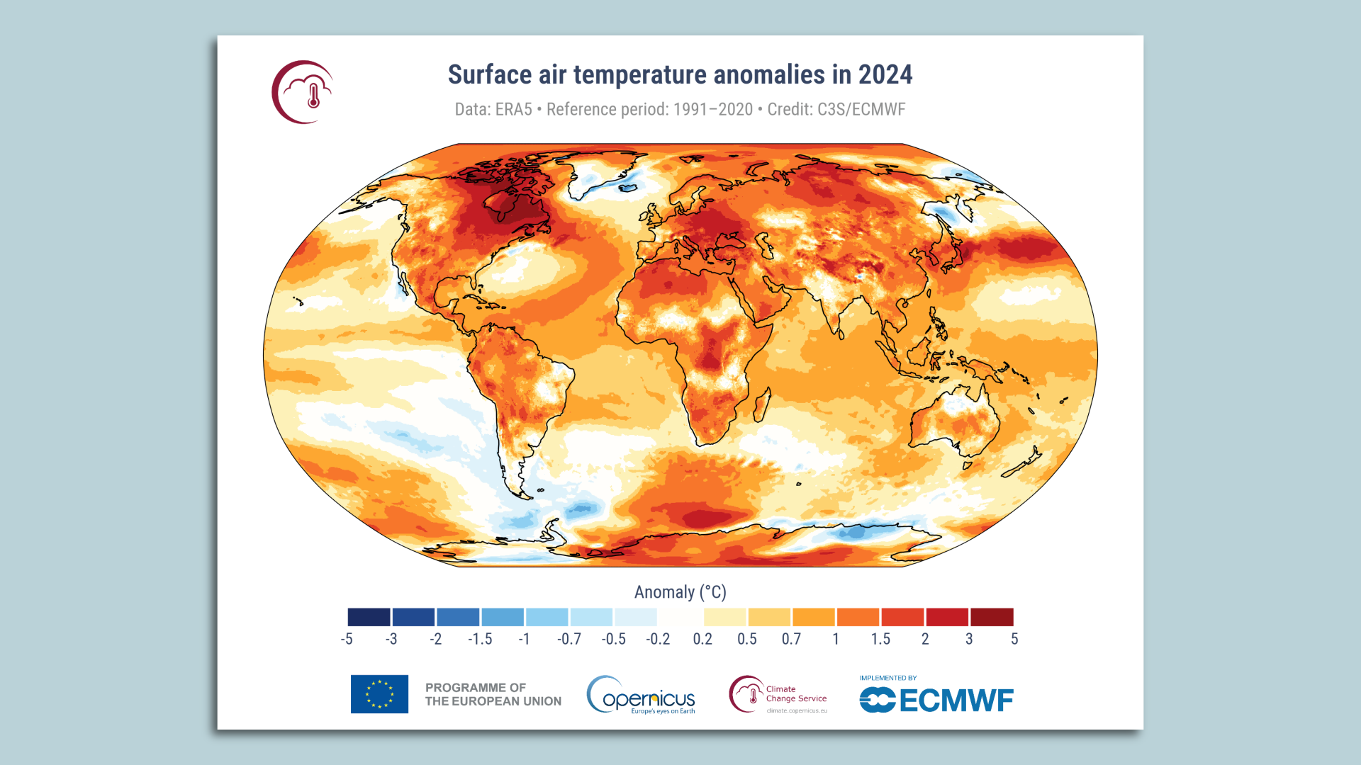
Map showing surface air temperature anomalies in 2024 compared to 1991-2020 average. Image: Copernicus Climate Change Service
Zoom in: Last year was the hottest seen in instrument record-keeping but also much longer before that.
In fact, as with 2023, the year was very likely the hottest in at least 125,000 years.
Some daily global average temperatures, as measured using increasingly precise computer model data, exceeded 2°C above preindustrial levels — flirting with another temperature target in the Paris climate agreement.
According to Copernicus, an agency of the European Commission, each year in the last decade has been one of the 10 hottest on record.
Global average surface temperatures in 2024 were about 1.6°C above pre-industrial levels, Copernicus found, and about 0.12°C (.22°F) above 2023's record high.
Data from U.S. centers, such as NOAA and NASA, show similar results. The World Meteorological Organization, a U.N. agency, also found that the global average surface temperature in 2024 exceeded 1.5°C above preindustrial levels.
Berkeley Earth, an independent temperature monitoring group that also released its 2024 data Friday, noted in a report that the record-breaking warmth of the past two years "demonstrates a clear deviation from the long-term warming trend, suggesting that warming rates have increased, at least in the short term."
Yes, but: The Paris Agreement's most stringent temperature target of holding warming to 1.5°C compared with pre-industrial levels refers to a long-term, 20-to-30-year average, rather than a single year or two.
Still, 2024 shows the world is already exceeding the barrier that diplomats set at the Paris climate summit in 2015, and in fact the average of 2023 and 2024 falls above the 1.5°C threshold, Copernicus said.
Studies show that if warming exceeds 1.5°C relative to preindustrial levels, the odds of potentially catastrophic impacts, such as the shutting of key ocean currents and melting of Arctic and Antarctic ice sheets, would increase considerably.
Regarding exceeding the 1.5°C marker, Copernicus' news release stated: "Global temperatures are rising beyond what modern humans have ever experienced."
Reality check: While global leaders are still committed to the 1.5-degree goal, it is partly because of a lack of consensus of what a new target should be.
Most climate scientists don't think the current threshold is feasible.
Berkeley Earth bluntly states as much in its report: "The Paris Agreement goal of limiting warming to 1.5°C will not be met, and the long-term average referenced by this target will exceed this threshold in the next five-to-10 years, conservatively."
What they're saying: "Humanity is in charge of its own destiny but how we respond to the climate challenge should be based on evidence," Carlo Buontempo, the Copernicus Climate Change Service's director, said in a statement.
"Whether it is at a level below or above 1.5°C of warming, every additional increment of global warming increases the impacts on our lives, economies and our planet," said WMO Secretary-General Celeste Saulo in a separate statement.
Between the lines: One of the most impactful records seen during 2024 was unusually high amounts of water vapor in the atmosphere, at about 5% above the 1991-2020 average, beating previous highs.
Extreme heat and high humidity is a deadly combination, and record large swaths of the globe saw "strong" to "extreme heat stress," per Copernicus' data.
The high water vapor content in the atmosphere also helped contribute to extreme precipitation events and to rapidly intensifying tropical cyclones such as hurricanes Helene and Milton.
The intrigue: Climate scientists are still investigating why 2024, which didn't feature 2023's planet-warming El Niño event on top of human-caused climate change, vaulted above the previous year on the list of hottest years.
Multiple studies have been published on this topic, and the possibility that the climate has shifted into a new phase of more rapid warming for reasons that are not yet completely clear is unnervingly still on the table.
What's next: Along with NOAA's and NASA's climate reports on Friday will come a new report on trends in ocean heat content.
All of it is likely to show evidence of a planet heating faster and to record levels.
Editor's note: This story has been updated with additional details and comments from WMO Secretary-General Celeste Saulo.
Map showing surface air temperature anomalies in 2024 compared to 1991-2020 average. Image: Copernicus Climate Change Service.
Zoom in: Last year was the hottest seen in instrument record-keeping, but also much longer before that.
In fact, as with 2023, the year was very likely the hottest in at least 125,000 years.
Some daily global average temperatures, as measured using increasingly precise computer model data, exceeded 2°C above preindustrial levels — flirting with another temperature target in the Paris Climate Agreement.
According to Copernicus, an agency of the European Commission, each year in the last decade has been one of the 10 hottest on record.
Data from U.S. centers, such as NOAA and NASA, show similar results. (Their final 2024 data comes out Friday.)
Global average surface temperatures in 2024 were about 1.6°C above pre-industrial levels, Copernicus found, and about 0.12°C (.22°F) above 2023's record high.
Yes, but: The Paris Agreement's most stringent temperature target of holding warming to 1.5°C compared with pre-industrial levels refers to a long-term, 20-to-30-year average, rather than a single year or two.
Still, 2024 shows the world is already exceeding the barrier that diplomats set at the Paris climate summit in 2015, and in fact the average of 2023 and 2024 falls above the 1.5°C threshold, Copernicus said.
Studies show that if warming exceeds 1.5°C relative to preindustrial levels, the odds of potentially catastrophic impacts, such as the shutting of key ocean currents and melting of Arctic and Antarctic ice sheets, would increase considerably.
Regarding exceeding the 1.5°C marker, Copernicus' news release stated: "Global temperatures are rising beyond what modern humans have ever experienced."
What they're saying: "Humanity is in charge of its own destiny but how we respond to the climate challenge should be based on evidence," said Carlo Buontempo, the Copernicus Climate Change Service's director.
"The future is in our hands — swift and decisive action can still alter the trajectory of our future climate."
Between the lines: One of the most impactful records seen during 2024 was unusually high amounts of water vapor in the atmosphere, at about 5% above the 1991-2020 average, beating previous highs.
Extreme heat and high humidity is a deadly combination, and record large swaths of the globe saw "strong" to "extreme heat stress," per Copernicus' data.
The high water vapor content in the atmosphere also helped contribute to extreme precipitation events, and to rapidly intensifying tropical cyclones, such as hurricanes Helene and Milton.
The intrigue: Climate scientists are still investigating why 2024, which didn't feature a planet-warming El Niño event on top of human-caused climate change, vaulted above 2023 on the list of hottest years.
Multiple studies have been published on this topic, and the possibility that the climate has shifted into a new phase of more rapid warming for reasons that are not yet completely clear is unnervingly still on the table.
What's next: Along with NOAA's and NASA's climate reports on Friday will come a new report on trends in ocean heat content.
All of it is likely to show evidence of a planet heating faster and to record levels.
As wildfires incited by high winds and record dry conditions ravage Los Angeles County, the National Weather Service is warning of continued high-risk weather to come both this week and next.
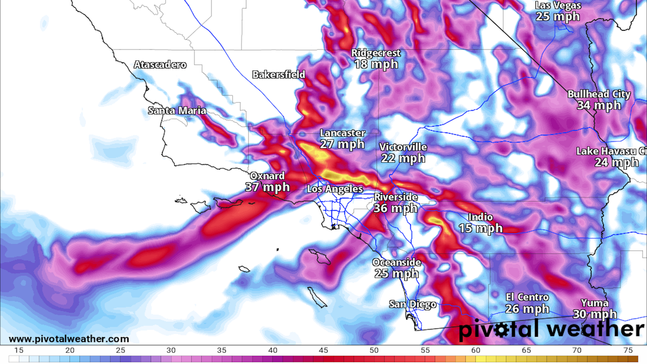
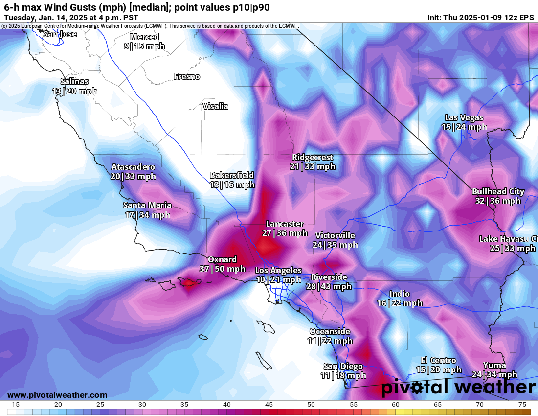
The big picture: Winds will once again pick up Thursday evening into Friday morning across the Los Angeles region, with damaging gusts in the foothills and the potential for additional fire spread, NWS forecasters said Thursday afternoon.
Forecasts call for wind gusts up to 55 mph overnight Thursday into Friday, and more high-wind threats are looming for LA County into early next week.
Computer model projections for median surface winds for Southern California on Jan. 14. Photo: Pivotal Weather
What they're saying: "Gusty Santa Ana winds will continue across the Southland into Friday, strengthening again tonight through Friday morning," NWS Los Angeles forecasters said in an online discussion.
"Another round of gusty north to northeast winds will develop between Saturday and Sunday, then a stronger offshore wind event is possible between Monday night and Tuesday."
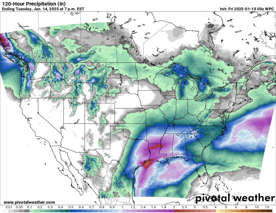
Forecast precipitation from the Weather Prediction Center for the lower 48 states, showing no precipitation likely for California through Tuesday. Photo: Pivotal Weather
Threat level: The Santa Ana wind event early next week looks particularly threatening due to a continued lack of rainfall, with computer model projections predicting that winds could reach well above 50mph.
"There is concern that fire weather conditions could become exacerbated given the antecedent conditions, little rain across the area since the Spring of 2024, and another offshore wind event on top of all of what we have seen, so far," NWS forecasters wrote.
"Residents are urged to stay tuned to latest information and remain vigilant in steps to protect your life and property."
Catch up quick: The Los Angeles County fires have burned at least 25,000 acres, been the cause of five confirmed deaths and placed almost 180,000 residents under evacuation orders.
Los Angeles Unified schools and offices will remain closed on Friday, with almost two dozen school districts also planning full or partial closures.


/2025/01/28/1738097937828.gif)