Wildfires erupt in L.A. as "life-threatening" Santa Ana winds hit Southern California
Los Angeles County saw multiple wildfires erupt as "extremely critical fire weather" from dry conditions and Santa Ana winds threatened Southern California into Wednesday, and the National Weather Service warned the worst was yet to come.
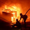
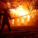
State of Play: The biggest blaze was the uncontained Palisades Fire. It triggered mandatory evacuations for at least 30,000 people in the Pacific Palisades area as it threatened multiple structures across at least 2,921-acres between Malibu and Santa Monica, where evacuation orders were issued Tuesday evening.
- More evacuation orders were issued as more fires erupted in L.A. County as the onslaught of the strongest Santa Ana winds arrived Tuesday.
- Other notable wildfires included the Eaton Fire near Pasadena, where evacuation orders were in effect as the blaze swelled to 1,000 acres at 0% containment in the Eaton Canyon area as of early Wednesday.
- Sylmar residents were evacuated from the Hurst Fire late Tuesday after the blaze ignited near where Interstate 5 and the 14 and 210 freeways meet about 10:29pm local time. It had grown to 100 acres as of 12:36am.
Threat level: Rare, late-season, "Particularly Dangerous Situation" red flag warnings are in effect as the region faces a life-threatening, destructive and widespread windstorm after months of dry weather that could produce hurricane-force gusts of up to 100 mph in some areas, per an advisory from the NWS' Los Angeles/Oxnard office.
- The NWS said on X an "extremely dangerous situation is unfolding in southern California tonight." The forecast was for widespread "DAMAGING WIND and EXTREME FIRE WEATHER for most of Los Angeles/Ventura Counties," the NWS said.
- "Time period of greatest concern: Tonight-Wednesday afternoon," it added. "Widespread N/NE gusts 50-80 mph, Isolated 80-100 mph mountains/foothills with scattered downed trees and power outages likely."
- University of California, Los Angeles, climate scientist Daniel Swain said on Bluesky that the situation was the worst since a destructive event in 2011 that saw fires in Pasadena and the surrounding areas.
- There's a "much greater wildfire risk" this time "due to far drier vegetation," Swain said.
In another sign of the seriousness of the situation, the Storm Prediction Center designated parts of the L.A. area as being in its highest risk category of "extremely critical" for Wednesday and Thursday.
By the numbers: The NWS' Los Angeles office has already recorded wind gusts at or exceeding 70 mph.
- These include Deer Creek Canyon (80 mph), Boney Mountain (76 mph), Corral Canyon Park (75 mph), Sandstone Peak (73 mph), Castro Peak (71 mph) and Rancho De Cielo (70 mph).
The big picture: President Biden said in a Tuesday night statement that he was being "frequently briefed on the wildfires in west Los Angeles" and his administration "will do everything it can to support the response."
- California Gov. Gavin Newsom proclaimed a state of emergency in response to the Palisades Fire on Tuesday. He and Cal Fire deployed resources to SoCal areas expected to be impacted by this windstorm and extreme fire risk due to high winds and low humidity, per Monday evening statements.
- Southern California Edison spokesperson Jeff Monford said in a Monday evening phone interview the utility had notified 411,000 customers that a public safety power shutoff could affect them on Tuesday and Wednesday.
- The utility's power safety shutoffs affected 22,236 customers in Los Angeles County and another 2,968 in Ventura County as of 7:30pm local time amid powerful winds, per the company's outage tracker.
- Monford said the issue was "not that the grid is vulnerable to wind," it's that objects could potentially become airborne and hit a power line and "cause a spark and because the vegetation on the ground an is so dry, that could be hazardous."
Context: Swain in a video briefing on Monday afternoon said parts of SoCal were "going on nine or 10 months now without meaningful rain. ... it's been the driest start to the season on record in some parts of Southern California, also the driest nine-month period on record in some of those same places."
Between the lines: Evidence suggests climate change is "increasing the overlap between extremely dry vegetation conditions later in the season and the occurrence of these wind events," said Swain during his briefing.
- That's because "if we'd gotten three or four inches of rain" before this event, "we wouldn't really be talking about the wildfire risk, about the wind damage potential."
- There's evidence that climate change "has already affected and will continue to accentuate changes in seasonal hydro climate, but not so much evidence, it's really affecting the winds themselves, or that it will necessarily in the future," Swain added.
What to expect: The strongest winds with gusts of 50 to 80 mph were expected into early Wednesday afternoon.
- Red flag warnings were coming into effect elsewhere in California on Wednesday, including in San Diego County from the morning through 6pm.
- Areas impacted by red flag warnings will face increased risks of extreme fire behavior and large fires with "VERY RAPID" spread, the NWS said.
Go deeper: Extreme wildfires doubled in frequency, magnitude since 2003
Editor's note: This article has been updated with new details throughout.


