Polar vortex-related frigid air, snowstorms likely to grip U.S. to start 2025
Areas of the U.S., including the South and Southeast, are likely to see frigid air that could break records by mid-month, along with potentially blockbuster winter storms.
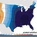
Threat level: Pieces of the polar vortex are projected to swirl southward out of northern Canada and into parts of the U.S. during early and mid-January.
- Accompanying the cold will be the threat of multiple significant winter storms.
- The weather pattern features a strong high pressure area over Greenland and a deep dip, or trough, in the jet stream across the East.
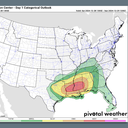
- This setup uniquely favorable for producing potentially significant snowstorms for the Southeast, Mid-Atlantic or Northeast.
Between the lines: The cold itself could present infrastructure challenges, depending on where the most frigid air sets up.
- The most extreme scenarios may pose risks of power outages in some states, but there is still considerable uncertainty about the magnitude of the cold and hardest hit areas.
- There are some broad outlines that are known this far out, however. Computer models have been signaling for days that the South, including areas from Texas to Alabama, as well as Southeast and Appalachians may see the brunt of the coldest air.
Overnight low temperatures below 0°F are possible in these areas during the coldest periods.
When the coldest weather may hit
The big picture: At least two rounds of extreme cold and storm threats are slated for the Midwest and Eastern U.S.
- The first should take place soon after New Year's, though this storm may produce a wintry mix rather than mainly snow across New England.
- Next up is the time period that meteorologists are eyeing closely for potentially significant East Coast winter storms, between about Jan. 6 through the 14th.
- Even without a storm or two, extreme cold will be on the move, crossing the U.S.-Canadian border and diving all the way to the Gulf Coast.
- The coldest air of the season so far and dangerous wind chills are expected across much of the Southeast from Jan. 7-13.
"Below freezing temperatures are possible as far south as the Gulf Coast and much of the Florida Peninsula," the National Weather Service's Climate Prediction Center warns. "Impacts to highly sensitive citrus crops are possible."
- Modeling and NOAA projections show that if the cold were to reach its full potential, temperatures may plunge to 25°F to 35°F degrees below average for this time of year during mid-January.
— NWS Climate Prediction Center (@NWSCPC) December 30, 2024
Zoom in: The polar vortex is an area of low pressure that exists over the Arctic at the upper levels of the atmosphere, in the stratosphere, during wintertime.
- Strong winds circulate counterclockwise around this low pressure area, and build up and trap some of the coldest air in the Northern Hemisphere across the Arctic.
Yes, but: When these strong winds slacken, parts of the polar vortex can detach and meander southward, bringing ultra-cold air to southern Canada, the U.S. and Europe.
- This most famously occurred during the winter of 2013-2014, and some computer models show this is likely to happen again in mid-January, with a piece of the polar vortex sliding from Minnesota to the Southeast.
- During this event, the stratospheric polar vortex is forecast to be "stretched" from north-to-south across the North Pole, rather than oriented as a tight circle.
- This could favor unusually cold weather and winter storms in the East, but it is not a classic setup for the coldest-possible event, according to meteorologist Judah Cohen of AER, a Verisk company.
Context: Numerous studies suggest polar vortex excursions may become more likely in a warming world, but this is still an area of active research.
- One such study, published in the journal Environmental Research: Climate, on Dec. 11, found that as global average temperatures continue to increase, due mainly to human emissions of greenhouse gases, cold air outbreaks in the midlatitudes could become more frequent.
- This study is unique since it puts forward a hypothesis of how such extreme cold events are becoming more likely, rather than just finding statistical correlations.
The bottom line: Extreme cold and snowstorms, capable of producing billions in economic impacts, are on the way for much of the U.S..
Editor's note: This article was corrected to show that, in the northern hemisphere, winds circulate counterclockwise (not clockwise) around low pressure areas.


